Meet your data where it lives.
ExposureHUB accepts data by file import, API integration or direct entry; geocodes every location; connects to catastrophe models and to RiskEnvision; and runs on your servers, in the Ebix private cloud or on a public cloud.
- File import, API integration or direct entry
- Every location resolved to a coordinate
- Your servers, Ebix's private cloud or a public cloud
However it arrives, it lands in one schedule.

Three ways in
One schedule
Three ways in, one schedule.
File import
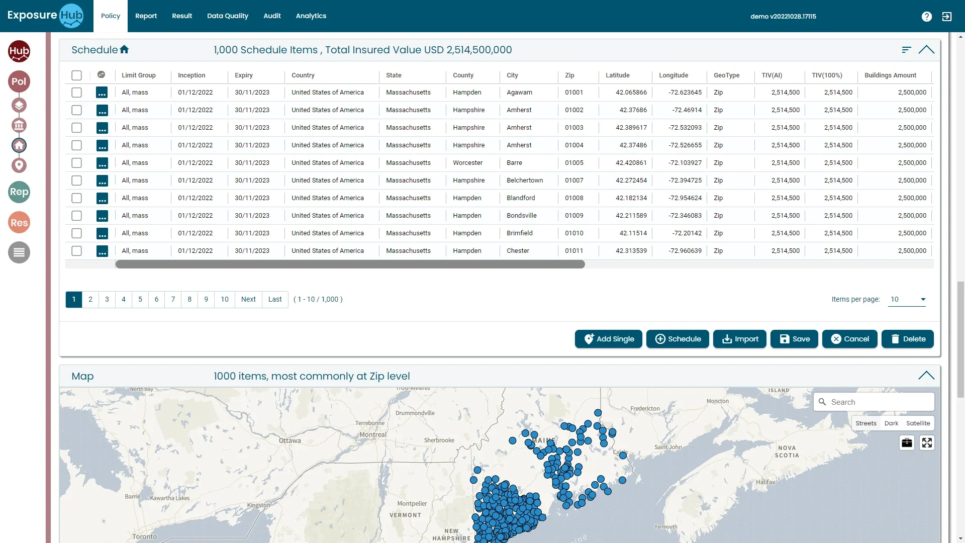
Load a schedule from a file with the Import button. ExposureHub normalises data from multiple carriers, brokers and systems into a consistent structure automatically.
Policy tab · ExposureHub demo environment
Incompatible formats in, one structure out.
Carrier file
Broker schedule
TPA extract
Normalised
automatically
Policy schedule
IllustrativeSource columns are invented examples; the platform columns are the real Policy schedule columns.
Every location, resolved to a coordinate.
Located
Location data enriched and validated with geocoding precision. Every row carries Zip, Latitude, Longitude and GeoType.
Mapped
Risk locations resolved to accurate coordinates for mapping, zone assignment and catastrophe model integration. The map reads “1000 items, most commonly at Zip level”.
Seen whole
Interactive maps: drill into specific geographies, identify accumulation areas and anticipate loss concentrations before events occur.
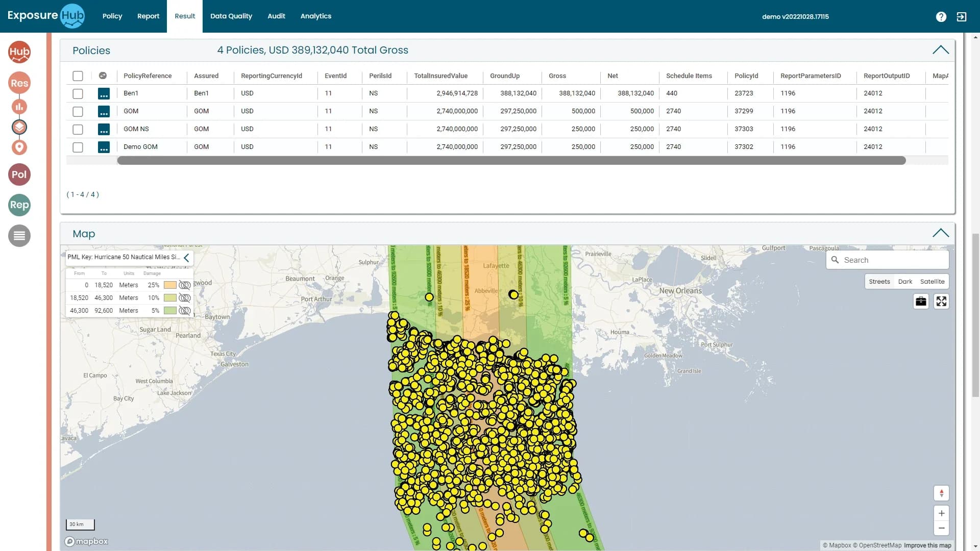
Policy and Result tabs · ExposureHub demo environment
Complement your catastrophe models.
Your exposure data
Validated policy schedules
ExposureHUB
the integration layer
External catastrophe models
Formatted out; outputs extend native analytics
Location data augmentation
Enriched location data comes back
Formatted and exported
Your exposure data can be formatted and exported for direct consumption by external models.
Native analytics, extended
Ebix works with specialist providers on integrations that extend ExposureHub's native analytics with industry-standard cat model outputs.
Location data, augmented
Third-party providers connect for add-ons such as augmentation of location data, and for integrating the latest models via specialists in their field.
Sources: ebixrisk.com, ExposureHub; Ebix Europe launch press release.
Exposure beside claims, reserves and TCOR.
ExposureHUB
RiskEnvision
Claims
RiskEnvision
Reserves
RiskEnvision
Total cost of risk
One operating picture
Organisations that need both claims management and exposure management can operate both platforms from a single Ebix relationship.
No manual exports
Data is shared between the two without manual exports or third-party connectors.
Entity and location level
RiskEnvision maps exposure across legal entity, location, business unit and coverage line; ExposureHub extends it with deeper accumulation modelling and scenario analysis.
Sources: ebixrisk.com, ExposureHub and Exposure & Asset Risk Management pages.
Host it your way. Same platform in every option.
The capability is the same wherever it runs. The choice is made during onboarding, based on your data governance and IT environment.
In-house
Ebix's specialists offer guidance and expertise if you want to host on your own servers.
- Your servers, your network
- Guidance from Ebix specialists
- Every module and screen
Ebix Private Cloud
Use Ebix's data centre to host ExposureHub; the Ebix team manages it on your behalf.
- Hosted in Ebix's data centre
- Managed by the Ebix team for you
- Every module and screen
Public cloud
Ebix can offer publicly hosted cloud computing services.
- Publicly hosted cloud services
- Offered through Ebix
- Every module and screen
Whichever option you choose, ExposureHUB connects to your upstream and downstream systems in the same way and complements your catastrophe models.
Talk to us about your data.
Tell us how your schedules are held today and we will show you how they reach ExposureHUB.